The World Map You Were Taught In School Is Completely Wrong, So Life's A Lie
If you once failed geography class, have no fear -- because the world map you were studying wasn't even accurate.
Don't freak out, though: The world is still round and there are still seven continents.
The main problem with maps we're used to is the size of the continents, and Boston schools are taking action to convert misleading maps that are hanging inside the classrooms.
Instead of the traditional Mercator map of the earth that we've grown used to, authorities are introducing the Gall-Peters-style map to students to better display authentic sizes of the continents.
Before I show you what the new map looks like, let's take a deeper look at the old one.
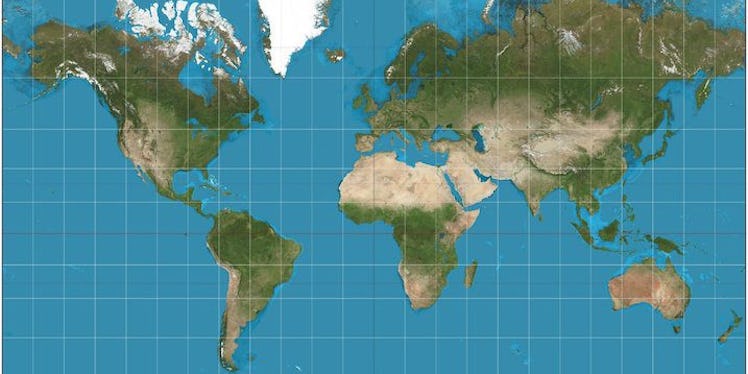
This is the Mercator map. Gerardus Mercator designed it in 1569, and we've used it ever since.
However, it appears Gerardus exaggerated the sized of a few imperial countries (like Europe and North America), and made them a lot bigger than they actually are.
He even went as far as shrinking the sizes of Africa and South America, causing a misleading representation of the accurate sizes of the land.
Boston schools are currently switching over to the Gall-Peters map of the earth, which more accurately displays the sizes of each continent.
Here's the Gall-Peters map. It was created by Arno Peters and was published in 1974.
Looks a little different, right?
Although the continents displayed on the "Peters projection," aka Gall-Peters map, are seemingly distorted, it displays the correct size of each body of land.
As you can see, Greenland (that little patch of white in the upper left hand corner) is a lot smaller than it appears on the Mercator map, and South America is even bigger. America, on the other hand, is even smaller.
These are just three changes in the map that students are going to have to re-learn in geography class.
It's been reported the new map will be introduced in one grade in elementary school, one grade in middle school and one in high school.
However, they will eventually be used in all grades, and students in Boston will be exposed to the truth behind the world map we've all depended on for 500 years.
Citations: Boston public schools map switch aims to amend 500 years of distortion (The Guardian), Boston schools have introduced a new world map — but it's just as wrong as the one you're familiar with (Business Insider)